

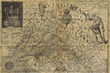
In the summer of 1608, John Smith led two expeditions out from the fort at Jamestown to explore and map the Chesapeake Bay. Smith describes these voyages of exploration in great detail in his The General History of Virginia, New England, and the Summer Isles, which also includes his famous map of the Chesapeake Bay. The map was made during these two voyages, and includes many details such as Indian villages, the homes of the different chiefs, and other valuable information about the region. |
 |
| In 1619, Sir George Yeardley became the governor of the colony. Yeardley arrived in Virginia with orders from the Virginia Company of London for a new form of government. The General Assembly, made up of Virginia Company-appointed councillors and locally-elected Burgesses, advised the Governor. The burgesses represented the four corporations and seven of the major private plantations in the colony. This was the first democratic assembly in the New World. | |
| In June 1624, King James I assumed responsibilty for the colony of Virginia after he dissolved the Virginia Company of London. He ordered Virginia's leaders to make a record of the colony's inhabitants and their provisions. This census-known as the 1624/5 Muster-is the first comprehensive account of households in British North America. In addition, it is the only extant census for seventeenth-century Virginia. The 1624/5 Muster is a house-to-house survey that contains information about the location of households in Virginia, the individuals in each household and the ties that connected the colony's early residents to one another. | |
| In 1634, the first counties were laid out to replace the old system of corporations and private plantations. | |
| Using Smith's General History and the 1624/5 Musters as guides, Virtual Jamestown has put together a map illustrating Virginia settlements in 1607, 1619, 1624 and 1634. They have been reconstructed as an interactive Flash map, and can be viewed by anyone with the Flash plug-in (Flash 5 or higher), available from Macromedia. To use the map, turn the layer buttons on and off by clicking on them. | |
| View the Patterns of Settlement Map | |
| Sources used in the creation of the Jamestown Patterns of Settlement map:
Haile, Edward Wright. Jamestown Narratives - Eyewitness Accounts of the Virginia Colony, The First Decade: 1607-1617. Champlain, Virginia: RoundHouse, 1998. (pgs. 254-278) Haile, Edward Wright. Virginia Discovered & Discribed by Captayn John Smith, 1608 - an adapted map by Edward Wright Haile identifying the John Smith locations on a modern map. The originals of the 1623/4 census and the 1624/5 Muster are in the Public Record Office, London, England. Hatch, Charles E., Jr. The First Seventeen Years: Virginia 1607-1624. Williamsburg: Virginia, 350th Anniversary Celebration, 1957. Jester, Annie Lash, comp. and ed. with Martha Woodroof Hiden. Adventurers of Purse and Person VIRGINIA 1607-1624/5. Third edition, revised and edited by Virginia M. Meyer and John Frederick Dorman. Richmond: The Dietz Press, Inc., 1987. Brown, Alexander. The First Republic in America. Boston: Houghton, Mifflin and Company, 1898. Morton, Richard L. Colonial Virginia. Chapel Hill: The University of North Carolina Press, 1960. Hale, John. S. A Historical Atlas of Colonial Virginia. Staunton, Virginia: Old Dominion Publications, 1978. | |